Wilgotność gleby, produktywność łąk i plony zbóż - ALOS-2 PALSAR-2
Assessment of soil moisture and productivity of grasslands and crops using PALSAR-2 data
Duration of the project: March 2016 - March 2019
Principal Investigator: prof. Katarzyna Dabrowska-Zielinska, Remote Sensing Centre IGiK
email: [email protected], phone: +48 22 3291974
The objective of the proposal is development of methods for the assessment of soil moisture and productivity distribution in the area of grasslands and croplands using multi-polarized PALSAR-2 data alone and in conjunction with Sentinel-1/2/3 data. Also, the method for monitoring the changes of grasslands and croplands production caused by drought will be developed.
The study will be carried out in Poland at two test sites: Wielkopolska Agriculture and Biebrza Wetlands. The wetland test site includes various grasslands and forests habitats. Authors will develop the algorithms for soil moisture and productivity (biomass, LAI) assessment applying various polarization and incident angles of microwave data and in-situ measurements of biomass, LAI, soil moisture, height of vegetation. In-situ data will be collected in the years 2016-2018 from April to October simultaneously to the satellite overpasses. As the second approach the "water cloud model" will be applied using PALSAR-2 and Sentinel-1 various polarizations. Microwave data will be applied independently or along with optical images for classification of crop types and grasslands communities.
Satellite derived variables will be used for the assessment of the state of particular ecosystems including drought detection and monitoring. Monitoring of the biomass changes will allow to depict the effect of climate change on biomass growth and on crop yield. The information on biomass and soil moisture will be further included in carbon sequestration model.
Anticipated results are developed methods as follows:
• Method for soil moisture assessment in the area of grasslands and croplands based on algorithms developed for microwave data (PALSAR-2 and/or Sentinel-1).
• Method for grasslands production (biomass) assessment based on algorithms developed for microwave data (PALSAR-2 and/or Sentinel-1) supported by optical data (Sentinel-2.3).
• Method for croplands production (yield of main crops) assessment based on algorithms developed for microwave data (PALSAR-2 and/or Sentinel-1) supported by optical data (Sentinel-2.3).
• Method for crop type cover mapping using different approaches for microwave data (PALSAR-2 and/or Sentinel-1) supported by optical data (Sentinel-2.3).
• Method for monitoring the changes of grasslands and croplands production caused by drought.


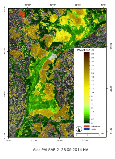
 Figure: Time series of vegetation height in 2016 modelled on the basis of PALSAR-2 (ALOS-2) microwave data. Credits: IGiK

